This story was updated Aug. 27, 11:50 a.m. to describe the university protocol in emergency weather situations.
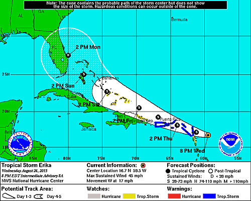
Tropical Storm Erika is barreling toward the Bahamas and has the potential to make landfall in South Florida on Sunday, but while preparation is necessary, projections vary and can change within a day.
According to Professor Nick Shay of the Department of Oceanic Sciences and Meteorology and Physical Oceanography program at the Rosenstiel School of Marine and Atmospheric Science, the “cone of uncertainty” that is seen in the National Weather Service’s projection model can have 200 nautical mile errors when forecasting four, five or six days in advance.
“The only thing it is telling you is that right now we are in the cone of uncertainty,” Shay said. “The cone of uncertainty just widens as you go out in the forecast, so as time goes on, that cone gets wider and wider and wider simply because the tracks are showing a lot of different tracks, for different types of reasons related to the environment.”
While Shay said that the storm is currently bigger than Danny was, it does not have a “well-defined eye, simply because it is running into a lot of sheer.” The sheer, which will determine Erika’s strength, is the difference in winds between the upper and lower layer of the atmosphere lying in front of the storm’s path, according to Shay. A large amount of wind difference between the layers would slow down the storm.
“It is going to run into a sheer layer just like Danny did; sheer in the atmosphere rips these things apart, so the sheer itself will be limiting the growth of this over the next two days … but if the sheer is weak, it could intensify.”
The bad weather will likely start Sunday afternoon if this track holds true, but he said that no one can tell yet whether that will happen. Shay said the biggest concern is how the storm will behave over the Bahamas, which are flat and surrounded by warm water, two factors that can potentially help the storm grow.
Shay wanted to remind South Floridians that forecasts this far in advance could be wrong, but that everyone should always be prepared for the storm. He said to gather water, batteries, canned foods and other emergency materials, just in case.
According to Scott Burnotes, the university’s director of emergency management, the Office of Emergency Management has been in contact with administration since Tuesday. If the storm continues to threaten South Fla., EM will start sending Storm Alert emails to students, faculty and staff with more detailed information about the potential hazards, safety tips and changes in normal operations. These Storm Alert emails are in addition to updates provided on the university’s main website.
“A basic rule of thumb is that we will allow residential students to shelter in place in the residential colleges and UV apartments for the lower classification of storms (Category Two and below),” Burnotes said.
In the case of a more intense storm, the university would ask students to evacuate the campus by a certain time or provide transportation to a nearby shelter or the airport.
Burnotes said students should be prepared for inclement weather by securing supplies, a form of transportation, an evacuation route and an out-of-state friend or relative to serve as a family contact.
Hurricane preparedness resources are available online at www.miami.edu/hurricane-
Featured image courtesy NWS/NOAA


